About Manaslu Trekking Route
If you are looking for an unexplored, less crowded, peaceful, and adventurous route for your holiday, then exploring this blog is going to be a very helpful guide for you. Manaslu Conservation Area, where one of the eight highest mountains in the world lies, has five known raw trekking routes, which nowadays are becoming popular after the Everest Base Camp trek and the Annapurna Circuit trek. Let’s learn about the five different trekking routes available in the Manaslu region. For trekkers researching permits, route variations, and seasonal logistics in the Manaslu region, consulting a licensed trekking agency in Nepal such as Master Himalaya Treks and Expedition Pvt. Ltd. can help ensure compliance with conservation and restricted-area regulations.
Best 5 Trekking Routes of Manaslu Region
These five trekking routes that we are discussing are open for trekking officially with different government permits according to the route and its geographical location.
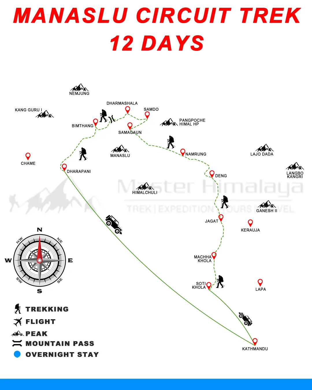
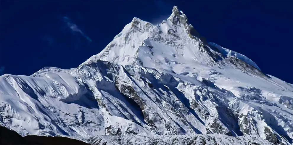
1. Manaslu Circuit (Larkey la) Trekking Route
The Manaslu Circuit Trek, also known as the Larkey La Pass Trek, is the most popular among the five. During this trek we make one complete round of the Manaslu conservation area. The starting destination of the trek is Machha Khola, and the end will be in Dharapani. Dharapani is also the starting point of another popular trek, the Annapurna Circuit. During the journey from Kathmandu to Maccha Khola, we drive there by either jeep or bus. It’s an off-road trip; travellers may need to change vehicles in between because there are many waterfalls along the route, and the road may get blocked by minor landslides sometimes. It is better to book a jeep from Kathmandu to Maccha Khola, which will be more comforting, but it may add a little bit to the cost. Since transportation and restricted-area permits are coordinated together for the Manaslu Circuit, working through an established trekking agency in Nepal helps streamline documentation and route planning.
Maccha Khola to Jagat Trekking Route
Starting from 850 m (Maccha Khola) to 1410 m (Jagat), it will take at least 6 hours if you can walk fast; the average calculated time is 7 hours, and it takes 8 hours for a slow walker. The first 2 to 3 hours of the trek follow a vehicle road that is frequented by local residents, schools, and various local vehicles; after that, you will enter a trekking route that includes crossing several suspension bridges and encountering numerous waterfalls. The last 3 hours involve a steep uphill climb, which prepares you for the following day and contributes to better sleep and rest.
Jagat to Deng
Starting at 1,410 metres in Jagat and ascending to 1,860 metres in Deng, this trek will take an average of 6–7 hours, though slower trekkers may take up to 8 hours. The route begins with a moderate descent through terraced fields and small villages, with glimpses of the Budhi Gandaki River alongside. The trail includes several suspension bridges, lush forests, and sections with stone-paved paths. The last part involves a steady climb, which prepares you for higher altitudes and helps you acclimatise. You'll pass by quaint villages such as Philim, a wonderful spot for a break or lunch.
Deng to Namrung
From Deng (1,860 metres) to Namrung (2,630 metres), the trek takes 6–8 hours depending on your pace. The route becomes more scenic, with the river gorges narrowing and views of lush pine forests emerging. After crossing several bridges and climbing gradual ascents, you’ll reach Ghap, a wonderful place to stop for refreshments. Beyond Ghap, the trail steepens, passing through serene forests and offering glimpses of the snowcapped mountains. Namrung is a culturally rich village where you’ll notice the Tibetan influence in the architecture and local customs.
Namrung to Shyala
The trek from Namrung (2,630 metres) to Shyala (3,520 metres) takes approximately 6–7 hours. The trail offers some of the most picturesque views of the journey. As you ascend, the terrain becomes more alpine, with fewer trees and more expansive views of the mountains, including Manaslu and other nearby peaks. You’ll pass through the villages of Lho and Sho, where you can explore monasteries and interact with the locals. Shyala is a quiet village with breathtaking panoramic views, making it a perfect place to relax and soak in the mountain scenery.
Shyala to Samagaon
This is a relatively shorter and easier trek, taking 3–4 hours from Shyala (3,520 metres) to Samagaon (3,530 metres). The trail is mostly flat, with some gentle ascents, allowing you to enjoy the stunning views of the Manaslu range. You’ll pass through yak pastures and traditional Tibetan-style settlements. Samagaon is a large and culturally significant village, where trekkers often spend an extra day acclimatising. Don’t miss visiting the Pungyen Monastery or taking short hikes to nearby viewpoints.
Samagaon to Samdo
From Samagaon (3,530 metres) to Samdo (3,875 metres), it’s a 3–4 hour trek with a gentle incline. The trail follows the Budhi Gandaki River and offers expansive views of the valley and surrounding peaks. The walk is relatively easy, giving your body more time to adjust to the altitude. Samdo is a small Tibetan village close to the Nepal-Tibet border, and it’s an excellent spot to explore the local culture or prepare for the higher altitudes ahead.
One of our trekkers from the UK specifically chose to spend extra time in this area — read their firsthand Manaslu Circuit Trek experience and tips to help plan your own journey.
Samdo to Dharamshala
The trek from Samdo (3,875 metres) to Dharamshala (4,460 metres) takes about 4–5 hours. The path is a steady ascent, with the terrain becoming more rugged and barren. Along the way, you’ll pass grazing yaks and see majestic views of the mountains. Dharamshala, also known as Larke Phedi, is a basic campsite where trekkers prepare for the challenging Larkya La Pass the next day. Facilities here are the most limited on the entire route — check our Manaslu Circuit Trek accommodation guide to know what to expect at each stop and how to book ahead. It's advisable to go to bed early for an early morning start.
Dharamshala to Bhimtang
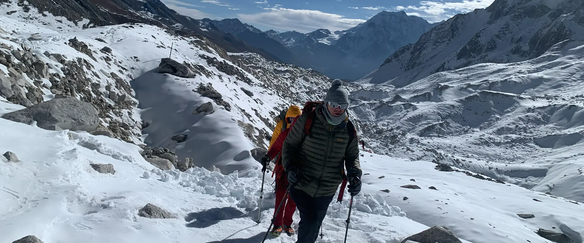
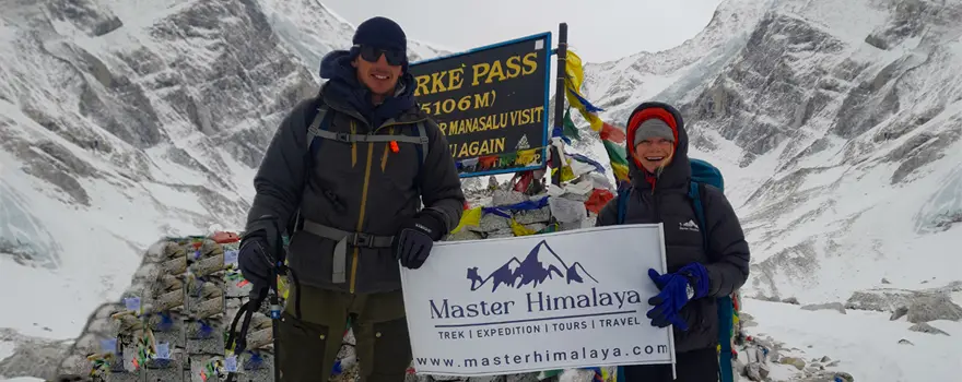
This is the most challenging and rewarding day of the trek, crossing the Larkya La Pass (5,160 metres). Starting early in the morning from Dharamshala (4,460 metres), it takes about 8–10 hours to reach Bhimtang (3,590 metres). The climb to the pass is steep and demanding, but the panoramic views of the surrounding peaks, including Himlung, Cheo, and Kang Guru, are spectacular. After crossing the pass, the descent to Bhimtang is long and requires careful footing. Bhimtang is a beautiful valley with stunning mountain views and comfortable lodges for rest.
Bhimtang to Dharapani
From Bhimtang (3,590 metres) to Dharapani (1,860 metres), the trek takes 6–7 hours. The trail descends steadily, passing through rhododendron and pine forests, with several river crossings along the way. As you lose altitude, the landscape changes, and you’ll re-enter more populated areas. Villages like Gho and Tilije offer opportunities for breaks and snacks. Dharapani marks the end of the trek, connecting to the Annapurna Circuit and roadways for transportation.
2. Tsum Valley Trekking Route
Manaslu Conservation Area offers another destination, the Tsum Valley, also called the 'hidden valley of Tsum', located near the Tibetan border. The route to the hidden valley of Tsum changes from Lokpa, which lies between Jagat and Deng along the standard Manaslu Circuit trek. Heading north from Lokpa, it takes about five days to reach Mu Gompa and a total of eight days to complete the trek and return to Jagat. Mu Gompa is the final destination of the Tsum Valley trek. Let’s discuss the route from Jagat to Tsum Valley.
Jagat to Lokpa
Starting at Jagat (1,410 metres) and heading to Lokpa (2,240 metres), this stretch takes 6–7 hours on average. The trail initially descends and crosses the Budhi Gandaki River, leading through lush forests and terraced fields. You’ll pass through villages like Salleri and Sirdibas, where you can observe traditional Gurung culture. The climb to Lokpa is steep but rewarding, with scenic views of cascading waterfalls and surrounding hills. Lokpa serves as the gateway to the Tsum Valley and offers serene surroundings and basic lodges.
Lokpa to Chumling
From Lokpa (2,240 metres) to Chumling (2,386 metres), the trek takes about 5–6 hours. The trail begins with a descent toward the Syar Khola River, crossing suspension bridges and navigating through dense forests. After the descent, the path ascends steadily, revealing glimpses of the hidden Tsum Valley. Along the way, you’ll pass small settlements and prayer flags signalling the region's Tibetan Buddhist influence. Chumling is a quaint village with monasteries and beautiful views of the Ganesh Himal range.
Chumling to Chokhangparo
Trekking from Chumling (2,386 metres) to Chokhangparo (3,031 metres) takes approximately 6–7 hours. The route involves a mix of gentle ascents and steep climbs, crossing suspension bridges and passing through traditional villages. You’ll notice an increase in the number of mani walls, chortens, and prayer wheels, reflecting the spiritual ambience of the Tsum Valley. Chokhangparo is a twin village divided into upper and lower sections, offering stunning views of the Himalayas and a chance to experience authentic Tibetan culture.
Chokhangparo to Nile
The journey from Chokhangparo (3,031 metres) to Nile (3,361 metres) takes 6–7 hours and is relatively moderate in difficulty. The trail passes through charming villages such as Lama Gaon and Pangdun, offering a peek into local life. The ascent is gradual, and the valley begins to widen, showcasing breathtaking landscapes and mountain views. You’ll also pass the Rachen Gompa, one of the most significant monasteries in the region. Nile, located near the Tibetan border, is the last village before Mu Gompa.
Nile to Mu Gompa and Back to Nile
From Nile (3,361 metres) to Mu Gompa (3,700 metres) and back, the round trip takes around 4–5 hours. The path is a steady uphill climb to Mu Gompa, the highest and most significant monastery in the Tsum Valley. Along the way, you’ll encounter expansive views of the valley, prayer flags, and small meditation caves. Mu Gompa is a peaceful and spiritual place, ideal for taking in the serene mountain atmosphere. After spending some time exploring the monastery and its surroundings, you’ll descend back to Nile for the night.
From Nile, we will trek down the same route to Jagat over three days and then drive to Kathmandu via Maccha Khola. However, many trekkers who explore the Tsum Valley continue their journey to the Larkey La Pass of the Manaslu Circuit trek.
3. Rupina la trekking Route
The Rupina La trekking route is the secondary route to the Larkey La pass. Instead of using the common route from Maccha Khola, we start our trek from Barpak and then trek to Nyak via Boudha Himal Base Camp to connect to the standard Manaslu Circuit trek route. Nayak lies between Jagat and Deng or just opposite of Lokpa. Nayak and Lokpa are the hills divided by the Budhi Gandaki River. From Nyak, we trek the same route as the Manaslu Circuit Trek to Larkya La Pass or the Tsum Valley route to the hidden valley of Tsum. Let’s discuss the route from Barpak to Nayak.
Kathmandu to Barpak
The journey from Kathmandu (1,400 meters) to Barpak (1,900 meters) takes about 7–9 hours by vehicle. This drive offers a mix of paved and rough roads, passing through scenic hills, terraced fields, and small towns. Barpak, also known as "Gorkha Village", is the starting point of this trek and holds historical significance as the home of Gorkha soldiers. The village is picturesque, surrounded by lush hills and offering views of snow-capped mountains like Buddha Himal. Barpak is a wonderful place to immerse yourself in local culture and prepare for the trek ahead.
Barpak to Gai Kharka
Starting from Barpak (1,900 metres) to Gai Kharka (2,900 metres), this trek takes about 6–8 hours. The trail begins with a steep ascent through dense forests and terraced fields, providing breathtaking views of the valley below. Along the way, you’ll pass through traditional villages and encounter locals going about their daily lives. As you climb higher, the terrain becomes more rugged, with rhododendron and pine forests dominating the landscape. Gai Kharka is a peaceful campsite surrounded by alpine meadows, ideal for an overnight stay.
Gai Kharka to Rupina La Phedi
From Gai Kharka (2,900 metres) to Rupina La Phedi (3,800 metres), the trek takes about 6–7 hours. The trail ascends steadily through rugged terrain, with sparse vegetation as you gain altitude. You’ll pass through rocky outcrops, glacial streams, and isolated yak pastures. This section prepares you for the challenges of higher altitudes. Rupina La Phedi is a basic campsite located at the base of Rupina La Pass, surrounded by towering peaks and offering a sense of solitude.
Rupina La Phedi to Baudha Himal Base Camp
The trek from Rupina La Phedi (3,800 metres) to Baudha Himal Base Camp (4,200 metres) involves crossing the challenging Rupina La Pass (4,610 metres). The journey takes about 8–10 hours, depending on weather and trail conditions. The climb to the pass is steep and demanding, but the panoramic views of the surrounding peaks, including Baudha Himal, are worth the effort. After crossing the pass, you’ll descend to the base camp, a serene spot with majestic views of glaciers and towering mountains.
Baudha Himal Base Camp to Jhong Kharka
From Baudha Himal Base Camp (4,200 metres) to Jhong Kharka (3,600 metres), it’s a 5–6 hour trek. The trail descends through rocky terrain and glacial moraines, gradually transitioning to alpine meadows. You’ll encounter pristine streams, lush valleys, and occasional wildlife such as blue sheep. Jhong Kharka is a remote campsite surrounded by natural beauty, offering a tranquil atmosphere for trekkers to rest and recharge.
Jhong Kharka to Nyak
The trek from Jhong Kharka (3,600 metres) to Nyak (2,300 metres) takes about 6–7 hours. This section involves a steady descent through dense forests, crossing rivers and suspension bridges along the way. As you lose altitude, the landscape becomes greener, and the trail passes through small villages and farmlands. Nyak is a quaint village located near the Budhi Gandaki River, where trekkers can reconnect with local culture and enjoy basic accommodations.
4. Manaslu circuit Trek and Thorong La Pass
This trek combines two of the most popular treks, allowing completion in approximately 21 days. Starting your trek from Machha Khola, you end up at Dharapani via Larkya La Pass in the Manaslu Circuit Trek, while Dharapani opens up another popular trekking route, the Annapurna Circuit Trek. This trek ends up at Muktinath, located in the Mustang Region via the Thorong La Pass. As we have already discussed the Manaslu circuit trekking route in the above section, let's discuss the Annapurna circuit trekking route.
Dharapani to Chame
From Dharapani (1,860 metres) to Chame (2,670 metres), the trek takes about 5–6 hours. The trail follows a gradual ascent through pine and oak forests, crossing several suspension bridges over the Marsyangdi River. Along the way, you’ll pass through charming villages such as Timang, with breathtaking views of Manaslu and Annapurna II. Chame, the district headquarters of Manang, is a bustling town with hot springs to relax in after a long day of trekking.
Chame to Pisang
From Chame (2,670 metres) to Pisang (3,200 metres), it’s a 5–6 hour trek. The route becomes more scenic as you follow a narrow trail carved into the cliffs above the river. You’ll pass through lush forests and open meadows, with striking views of Lamjung Himal and Annapurna II. As you approach Pisang, the landscape becomes drier, and Tibetan-style architecture becomes more prominent. Pisang offers two parts—Lower and Upper Pisang—with Upper Pisang being more traditional and offering better mountain views.
Pisang to Manang
The trek from Pisang (3,200 metres) to Manang (3,540 metres) takes 6–7 hours. There are two routes: the lower trail and the more scenic upper trail through Ghyaru and Ngawal. The upper route offers stunning views of the Annapurna range and is worth the extra effort. As you trek, you’ll notice a stark change in the landscape, transitioning to a high-altitude desert. Manang is a lively village with numerous tea houses, bakeries, and shops, which makes it an excellent place for acclimatisation.
Manang to Ledar
From Manang (3,540 metres) to Ledar (4,200 metres), the trek takes about 5–6 hours. The trail gradually ascends, offering stunning views of the surrounding peaks, including Annapurna III and Gangapurna. You’ll pass through Yak Kharka, a small settlement where yaks graze in the alpine meadows. The higher altitude becomes noticeable here, so take it slow and stay hydrated. Ledar is a small village with basic lodges and spectacular mountain vistas.
Ledar to Thorong Phedi/High Camp
The trek from Ledar (4,200 metres) to Thorong Phedi (4,540 metres) or High Camp (4,800 metres) takes 4–5 hours. The trail becomes steeper and more rugged as you approach Thorong Phedi, the base for crossing the Thorong La Pass. Some trekkers choose to stay at High Camp for a shorter ascent the next day. The landscape is barren yet striking, with towering peaks and glacial streams surrounding the area.
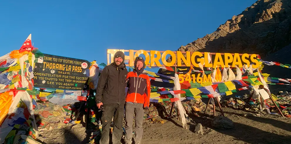
Thorong Phedi to Muktinath via Thorong La Pass
This is the most challenging and rewarding day of the trek, crossing Thorong La Pass (5,416 metres). Starting early in the morning, the trek from Thorong Phedi (4,540 metres) or High Camp (4,800 metres) to Muktinath (3,760 metres) takes 8–10 hours. The climb to the pass is steep and hard, but the views of the Annapurna and Dhaulagiri ranges are unforgettable. After reaching the pass, the trail descends sharply to Muktinath, a sacred pilgrimage site for Hindus and Buddhists. The temple and eternal flame are highlights of this serene village.
Drive Muktinath to Pokhara
From Muktinath (3,760 metres), it’s a scenic 8–9 hour drive to Pokhara (820 metres) via Jomsom, Tatopani, and Beni. The road journey offers stunning views of the Kali Gandaki Valley, terraced fields, and waterfalls. You’ll also pass through the world’s deepest gorge, carved by the Kali Gandaki River. Pokhara, with its lakeside charm and panoramic mountain views, is the perfect place to relax after completing the trek.
5. Manaslu circuit trek and Tsum valley Trekking Route
We have already discussed the route of the Manaslu Circuit Trek and of Tsum Valley above. This trek combines both the Manaslu Circuit and Tsum Valley routes, making it the most preferred option among all the treks. Because this itinerary passes through restricted areas such as the Manaslu Conservation Area and Tsum Valley, trekkers must obtain special permits and travel with a government-registered trekking agency in Nepal, such as Master Himalaya Treks and Expedition Pvt. Ltd., in accordance with Nepal’s trekking regulations. Only those who lack time skip the hidden valley of Tsum. We start our trek at Maccha Khola, then proceed to Jagat and Lokpa, trekking towards Tsum Valley before returning to Lokpa and Jagat, and finally continuing towards Larkya La Pass, where we will end our trek at Dharapani. From there we return by road transportation to Kathmandu via Besisahar.